
Home
About Us
Kodaikanal
Attractions
Kodai Map
Eatout
Reservation
Transportation
Contact

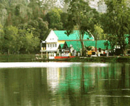


Lake:One of the main attractions for the tourists of Kodaikanal is the Kodai lake which is at a distance of 3kms from the bus stand. In 1863, Vera Levinge, a former District Collector of Madurai settled in Kodaikanal after his retirement. He was the man of resource and creative ideas for this lake. By spending his own money he converted the marshy land with several streams of lake by constructing a strong bund and brought boats from Tuticorin. It is reported that the foreign resident’s even used to swim in the lake.
The lake is situated at 10 deg 14′ n latitude and 77 deg 28′ longitude at an elevation of 2285m above sea level and it looks magnificent with star shaped glittering water, in the midst of evergreen lush slopes. The hills receive the rainfall during North-East Monsoon months of October, November and December. The lake is spread over 60 acres and surrounded by fine tarred road of 5 kms length, the maximum depth in 1962 was 11.5m but it is now about 9m due to siltation. The average depth is 3.0m. The boat club provides boats for hire. There are luxury boats also. The famous Carlton hotel is facing the lake and the hotel is having their our boats for their customers.
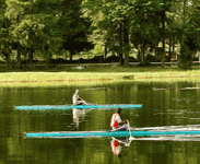
Today lakhs of tourists walk around, sail on, ride on horses & cycles and admire the lake. Fishing can also be done obtaining permission from Inspector of Fisheries. Ponyrides by children and adults walking around the lake are part of Kodai Holiday.
Berijam Lake:Berijam Lake is one of the beautiful picnic spots in Kodai, located 21-km away from the bus stand. This lake supplies drinking water to Periakalam town. The scenery around here is delightful. It spreads over an area of 24 hectares.
Parks:
The practical utility of this park is, in every May a horticultural show is conducted by the department of Horticulture. On that occasion enormous vegetables and flowers from neighbouring villages compete for the prizes, which draws big crowd. They exhibit flowers, vegetables, fruits and other products. It serves as a practical centre for education on Ornamental Horticulture and as a demonstration centre. The various methods of training, pruning, budding, grafting, potting seed collection etc, are taught to the students of Horticulture as well as to the visitors.
Chettiar Park:
Chettiar park, managed by the township, is on the way to the Kurunji Temple. It is 3.2 kms from the Bus Stand. Unlike other areas this park is very quite, and those who love calm timepassing can prefer this park.
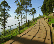
Coakers Walks:It is a narrow pedestrian path, constructed by Lt. Coaker in 1872, a one kilometer mountain road which runs along the edge of steep slopes on the southern side of Kodai road which is 1/2km away from Kodai. The walk winding around mt. Nebo starts near van Allen hospital and joins the main road above St. Peter’s Church provides a wide-angle spectacular view of the plains. On a cloudless, clear day one can have interesting sights, such as…. Dolphin’s nose in south, valley of the pambar river in South East, birds eye view of Periyakulam and even city of Madurai.
One must be aware of a fascinating phenomenon called ‘Brachem Spectre‘ . A very lucky person can see his shadow on the clouds with a rainbow halo, when sun is behind and cloud and mist is in his front.
Bryant Park :
Bryant Park is a botanical park situated on the eastern side of the lake. It was landscaped and stocked by a British officer after whom it was named. , It is noted for flowers, hybrids and rafts. Varieties of flowers can be seen in a glasshouse. Cut flowers are exported from here. In month of May, the annual horticultural show in held here.
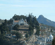
Kurinji Andavar Temple:
This temple situated 3 kms from the lake, is a famous shrine dedicated to Lord Muruga. In Tamil literature Kurinji means ‘hill region’ and Andavar means ‘God’. Hence Lord Muruga is referred as ‘God of hill’. This temple is associated with the Kurinji flowers, which carpets at hill sides and bloomes once in 12 years. From this temple one can have a view of Palani and Vaigai dam.
Kurinji Poo (Flower) :
It is flowering once in 12 years. It last flowered in the year 1992. During that flowering period the honey from this place will be good for health.
Other Temples
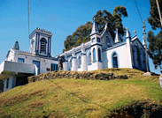
The Mariamman Temple, Vinayagar Temple, Murugan Temple, two mosques at Ellis Villa and Munjikal, sacred Heart Church, Munjikal, Francis Xavier Church, Gorapur, St. Mary’s Church, Lassalette, St. Joseph’s Church, Luthern Mission Church, Lake End, offer the devout a relaxed and genteel place to pray.
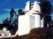
Physical Observatory:
This oldest world famous institution was built in 1898. It is nearly 6 kms from the bus stand and situated at the highest point in Kodai hills at 7700 ft. It has a well equipped productive laboratory doing quality research work. Its director Evershed discovered the phenomenon of radial motion in Sunspots – known as Evershed effect.
40 Miles Rounded:
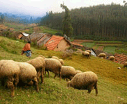
For the visitors enjoying long hiking and trekking, a wonderful 3 to 4 days trek is available with delightful path. The usual trek follows from Berijem lake to the Kerala border Vandaraw and will be back via ‘Poondi’ , Kavunji, and Kukkal. We can see the big Mannavanur sheep farm while trekking via this route.
One has to hire a local guide to avoid missing of routes. The view of the cliffs is breathtaking. Several mountain streams with panoramic view can be seen. Previously permission should be obtained from District Forest office for stay in forest rest houses. Food should be brought while trekking since only tea shops are available at villages in between.
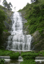
Falls:
Silver cascade:
This water fall is located on the main ghat road, 8 kms away as one approaches Kodai from Kodai Road. Overflow of Kodai lake takes 180 ft leap over a steepcliff, to crash into a pool beside the ghat Road.
Bear Shola Falls:
An ideal picnic spot 1.6 km from bus stand and within 2 Kms off the lake, where once bears came to drink water. Hence the name of the falls became Bear Shola falls. Cross the lake bund, pass the Telephone exchange on your right, and at the junction take the lower road there comes Clifton Hotel. The approach is rugged hill path. The falls are at the best in rainy season.
Pambar Falls:
“Grand cascade” is another name for this magnificent falls. It can be reached by a steep, precipitous path behind Pambar house. Racing down Pambar Raivine is Zig-zagging leving stream that cascades over a series of rock formations. It is 4kms away from Kodaikana
Thalaiyar Falls:This is also called as Rat tail falls.The widest falls, ranging from 13th kilometer on the ghat road to kodai.It is one of the highest falls in India, with their 975ft sheer drop.Notes
Tourists are advised not to take bath in the falls though it tempts by its beautiful look as it has been polluted from its starting point all the way down.
Telescope Houses:
To enable the visitors to have a panoramic view of the valley and the nearby towns, two telescope houses have been put up at Kodai.
Kukkal Caves:
To reach Kukkal Caves which is at a distance of 40 kms, travel by bus upto Poombarai and then give a walk. It is preferable to take a local guide. After walking through geranium plantations, pine and wattle forest, the Kukkal forest rest house can be reached. The early morning hike from the rest house will lead to beautiful shola with wild large orchids. One should be beware of leeches. The caves here are actually overhanging slabs of rocks. This rock shelter is at an altitude of 1500 m.
The cave reveals traces of earliest settled tribals, Paliyans who used to wear leaf clothing. Overviewing the caves are Manjampath valley where bisons can be seen.
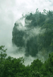
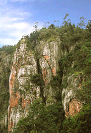
Pillar Rocks:
Three granite boulders each vertically measuring a height of 400 feet stand shoulder to shoulder. It is located 8 Kms from the lake tower over the panoramic view. In the shadows of the pillars are shady woods that invite picnickers. The chamber between the two pillars is called Devil’s kitchen.
Dolphin’s Nose:
To reach Dolphins nose at a distance of 8 kms from the bus stand, one has to follow the route specified here.There is an old road after crossing Pambar Bridge near levinge stream. A rough curve rounds the hillside which leads to a point where a flat rock projects over an awful chesm of 6600 feet deep. This is Dolphins nose. On the way, beautiful views of plains and steepy rocky eascarpeints called rolling hills can be seen. The old village of vellagavi can be reached through the rugged bridle path.
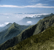
Vembadi Peak:
Vembadi Peak is the second highest peak with a height of 2466m. A right turn in Berijam road and a steep climb leads you to the top. From the stone summit, one can have a magnificent view over Berijam lake, Vandaravu range, Mannovanur sheep farm , Poombarai valley and over all Kerala. The hike will begin from Kodaikanal TV Tower.
Palani Hills:
The Palani hills are at eastern offshoot of the Western ghats covering an area of 2400 Sq. Kms, and the town of Kodaikanal is centrally located. There are 2 main divisions of Palani – the Upper Palani (1800 – 2500 m)and the Lower Palani (800 – 1500 M). The Palani is the main watershed for the Vaigai (South) and Amaravathi (Cauvery) (North) Basins. The climate of the Palani varies with altitude from the typical climate of the Tamil Nad. The average rainfall in Palani is 1600 mm. The major contribution being from the North East monsoon though there is some rainfall during the South West monsoon period. The Palani is a source of unique genetic diversity as well as of water for the thirsty plains below.Shenbaganur Museum:
Shenbaganur Museum is located about 5 Km from the lake. The Sacred Heart College maintains this museum. One of the best orchidoriums in the country with more than 300 species of orchids exotic plants and wide-ranging collection of birds are found here.
Interesting Feature
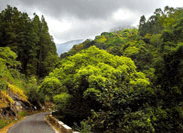
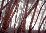
One of the most interesting features of the Vegetation is the ever green shola forest (wet, temperate) from which originate many perennial streams. Sholas are probably one of the most valuable treasures of the hills as prime watershed and as shelter for wildlife, in addition to being the terminal refuge for endangered species of flora and fauna e.g. Loya, Orchids, Nilgiri tahr, Grizzled giant Squirrel etc.,Governing Authority :
There are 15 revenue villages having a population of around 95000 including Kodaikanal Township (30000).Several organisations including the Palani Hills Conservation Council (PHCCfor short) have been seriously engaged in protecting the most fragile ecosystem of these hills.
Trekking Routes:
Motorable roads have the terminus in bold face, merely jeep ones have them in italics, approximate distances are indicated in brackets when known; when no roads exist, the time required for footing the distance is indicated.
In general some 9 hours (8 a.m. to 5 p.m.) were spent to cover the distance but this includs the time for plants collecting. Freelance trekking should need only 2/3 of the time.
Kodaikanal-Batlagundu (55 Km): Law’s Ghat Road. Perumalmalai-Palamalai(8km) – Thalayar (90 mins.)- Manjalar (150 mins.)-Devadanappatty(6km).
Shembaganur-Korappur-Adukkam(180 mins.) – Selumbathope (120 mins.) – Kumbakkarai – Periakulam (10km).
Shembaganur-Vengayapparai (Coolie or telegraph path); A.G.Bourne’s “Kodaikanal Ghat” (4 hours)-Kumbakkarai – Periakulam (10Km).
Kodai-Dolphin’s Nose-Vellagevi-Vengayapparai (left of Vellagevi) (300 mins.)-Kumbakkarai-Periakulam(10Km.) Kodai-Dolphin’s Nose-Vellagevi-Kumbakkarai (right of Vellagevi) (300 mins.)-Kumbakkarai-Periakulam (10 Km).
Kodai-Green Hut (12Km) (along the ridge for 30 mts) – down to Chinnur-Periakulam (300 mins.)
Kodai-Thoppithookkipparai (near Berijam) (16Km) – Periyur (3 hours) – Sothupparai – Periakulam (10 Km). Kodai-Karthirikkai Odei (40Km) – Sinna Sothupparai – Athirikkarappankoil – Oral muthu – Valasal aaru – Bodinayakanur (6 hours).
Kodai-Berijam (23 Km) – Konalar (5 Km) – Sebastian Odei (3 Km) – Marion Shola (2Km) – Kathirikkai Odei(1 Km) – Kambippalam (3 Km) – Pulavachiar (5 Km) – Vandaravu (10 Km) – Top Station (10 Km) – Central Station (2 hours)
Kurangani (Bottom Station) 3 hours – Bodinayakanur (17 Km). Kodai – Mannavanur (35 Km) – Keelanavayal (90 mins.) – Manjampatty (3 hours) – Thalinji (2 hours) – Champaked ( 90 mins.)-Chinnar (5 Km) – Udamalpet (32 Km) – Palani (37 Km).
Kodai – Paricombai (27 Km) – Kukkal (8 Km) – Kuthirayar-Pappanpatty-Kavalapatty (7 hours) – Palani (23 Km.) Kodai – Puthur (43 Km) – Bonthampally (24 mins.) – Kavalppatty (9Km) – A-Kalaiamputhur (9Km) – Palani (5 Km.)
Kodai – Pallanghi (10 Km) – Thalamalai – Porandalar-Palani.
Kodai – Vilpatty (8 Km) – Ganesapuram-Puliamarathope (240 mins.) – Palani (13 Km).
Kodai-Perumalmalai (13 Km) – Pethupparai (6 Km) Ganesapuram-Puliamarathope (240 mins.) – Palani (13 Km). Kodai-Perumalmalai-Palani Ghat road (60 Km).
Kodai-Tandigudi (40 Km) – K.C.Patty (20 Km) – Asarippatty – Bethelpuram-Parappalar-Thalayoothu – Viruppachi.
Kodai- Tandigudi (40 Km) – K.C.Patty (20 Km) – Pachalur (10 Km) – Oddanchatram (31 Km).
Kodai – Tandigudi (40 Km) – Adalur (15 Km) – Panrimalai (4Km)-Alagumalai (5 Km) – Puducombai (14 Km) – Karisalpatty (7 Km) – Vattapparai (4Km) – Melpatty (2 Km) – Anandarayamkottai-Pithalapatty (2Km) – Dindigul (7Km.).
Kodai – Tandigudi (40 Km) – Thadiankudisai (10 Km) – Btlagundu (33 Km.)